
Previously, we explored some possible root causes of why Albany’s grocery access landscape looks the way that it does as of this writing, including population dynamics, historic grocery locations, and the ultimate consolidation of most store locations to their present spatial cluster. In this post, we will explore potential paths forward, from the purely theoretical to the more practical.
If someone said “yes” to a new store, where would you put it?
The simplest way to answer this question is to start from a place of pure geography, treating all other factors as equal. They are not, and we will address that fact later in this post. Two zones of greatest opportunity were established in earlier posts in Central and South Albany based on the fact that proximate grocery access within these zones would immediately boost them into the highest category of walkability in our index model. Using the centroid of each zone, we can approximate where the addition of a new store might have the greatest reach in a walkshed, and therefore the greatest impact:
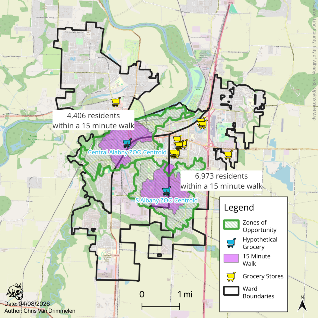
While placement of a grocery story of any type would not cover the entire Zone of Opportunity (ZOO) with a 15 minute walking service area, we can see above that doing so would theoretically address the maximum number of residents in each ZOO with a single store, and would likely boost practical walkability even along the periphery of the zones even outside of the 15 minute threshold.
This approach, however, intentionally ignores reality in favor of simplicity on the question of “where,” as these areas of Albany in particular are fully “built out,” and land for a grocery store in these locations is neither vacant nor available. As statistician George Box said “All models are wrong, but some are useful.” This model of an “ideal location” is wrong in that one cannot simply parachute a grocery store into a previously developed neighborhood or commercial area without redevelopment, but it serves as a useful starting point.
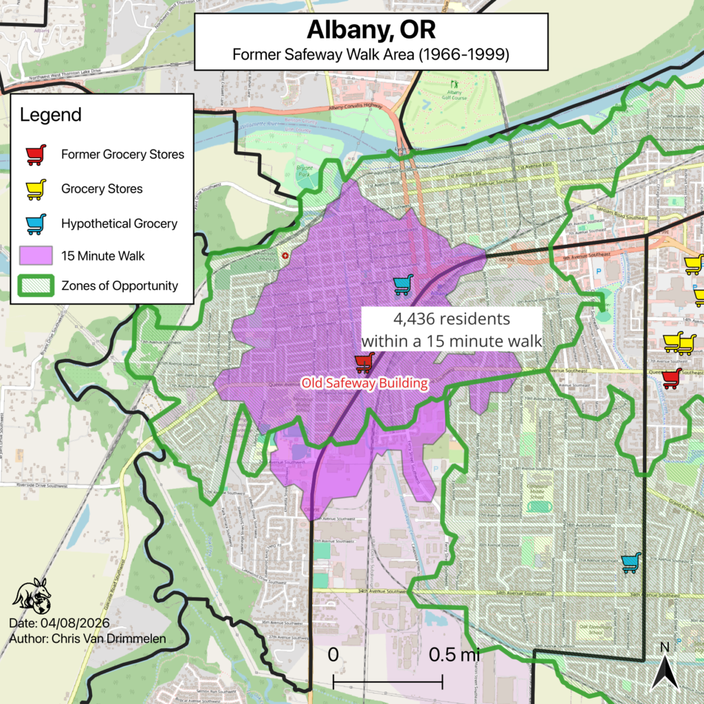
While the precise centroid of neither zone falls on a useable, vacant parcel for a grocery store, it is, however, worth noting that the centroid of the Central Albany Zone of Opportunity in particular falls very close to the location of the location of Albany’s Safeway store as it existed from 1966-1999 (discussed in the last post):
While the actual former store site sits farther south than the zone’s centroid, resulting in different walk service area geometry, the number of residents covered by said service area is very similar and occurs almost entirely within the Central Albany Zone of Opportunity, further highlighting just how ideal of a location this former grocery store occupied, and how much of a loss occurred in this part of the Albany community in 1999 when Safeway elected to move to its current location in what became a tight cluster of nearly all grocery services in the whole city. As previously discussed, this location is not available for real life consideration at this time as it has been leased to the Adult & Teen Challenge Thrift Store, which is at least a much better use than the building sitting vacant.
Addressing Real Life Considerations
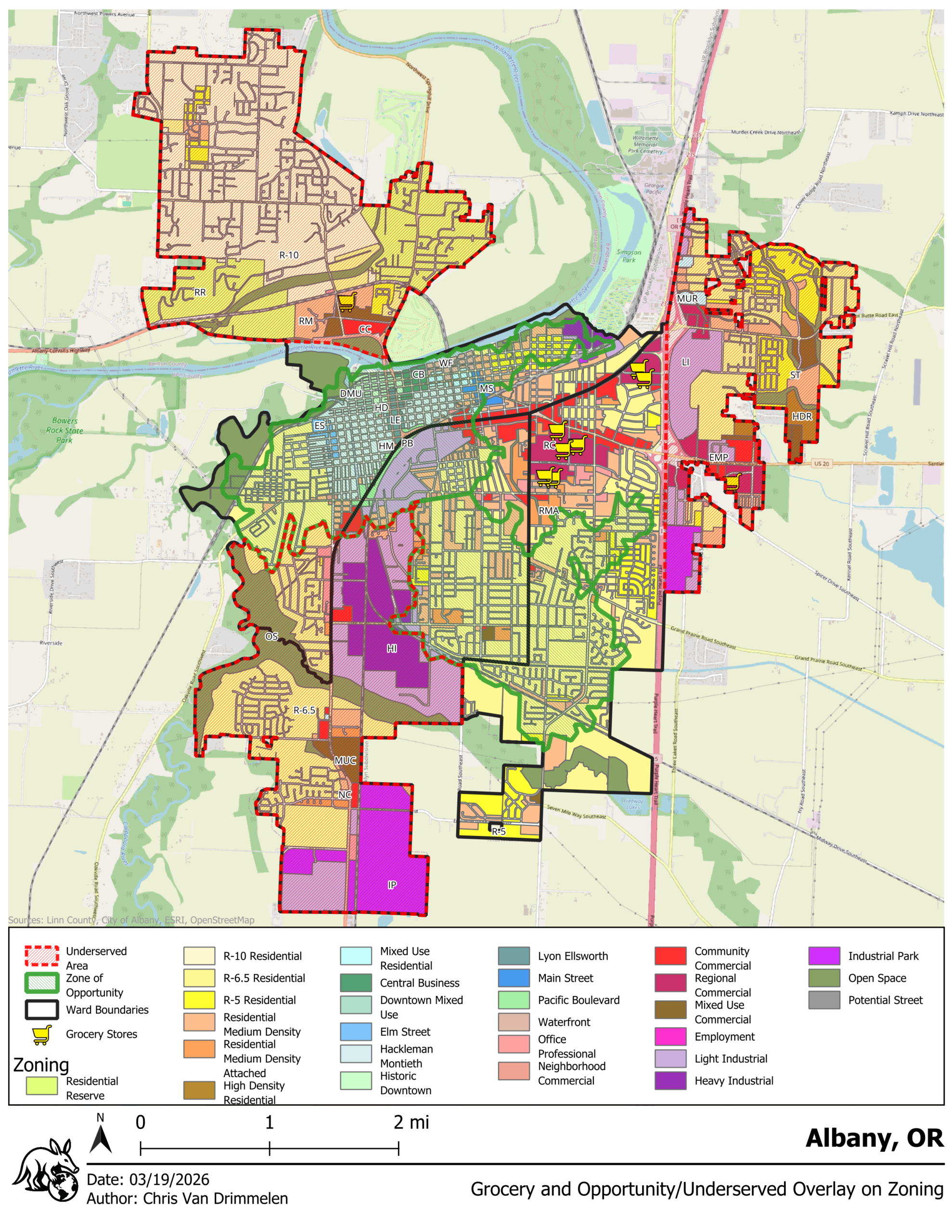
When selecting a location for any type of physical facility, one of the first considerations that must be taken into account is the applicable zoning code for the jurisdiction in which one plans to operate. Zoning defines what is allowed in a particular location, either outright, with planning approval, or as a “conditional use” (essentially a full or partial exception to zoning requirements). A city or county’s zoning map can be seen as a statement of spatial priorities, much like its budget is a statement of the jurisdiction’s financial priorities.
While the above map is information rich and therefore a little visually “busy,” it is useful to overlay several different things simultaneously to reveal patterns on this topic. The full zoning map for the city is displayed, with overlays for earlier identified underserved areas and zones of opportunity related to walkability, along with current grocery store locations.
Grocery stores being a commercial endeavor, occur at present within commercial zones, specifically Regional Commercial in almost all cases, with the North Albany IGA occurring within a Mixed Use Commercial zone. Community Commercial could also be a candidate for traditional supermarkets, with Neighborhood Commercial potentially also serving as a candidate for smaller format stores. In theory, conditional use could allow a grocery retailer to operate in some other zoning categories, particularly those falling within the “Town Center” zoning class, which include some additional mixed-use zone types, however, treating a zoning map as a statement of priorities, it is important to take the perspective of an outside entity reviewing said map and code as such.
Where zoning appropriate to outright use by a grocery retailer exists on the map should be treated as “where the city wants this” and where it does not should be treated as the opposite.
Filtering the above zoning map layer to only zones within the commercial class quickly tells the reader where some of the issue of tightly clustered grocery access has come from over time. The area around Albany’s primary cluster of grocery stores is also the area found in the walk index analysis to be the most walkable. This is also where the majority of Albany’s commercial zoning occurs. This clustering, therefore, cannot be treated as an accident or merely the product of retailer behavior entirely outside of the community’s control.
Some commercial zoning occurs within the three underserved areas, but as previously noted, all three underserved areas have a lower population density than areas closer to the geographic center of Albany, so they may be less attractive to grocery retailers under current conditions, particularly in light of previously discussed shifts in how grocery markets work nationwide.
What is startling, however, is the near total lack of commercial zoning within the two identified zones of opportunity. Central Albany, having a longer history, including the original platted townsite of Albany, is more complicated given the tension between historic preservation and the needs of modern grocery retailers. Much of downtown Albany and its Central Business District fall within the “town center” zoning class rather than strictly “residential” or “commercial,” but the fact remains that facilities in that area would, at best, accommodate a small format store with limited vehicle parking and delivery truck access unless a site similar to the Old Safeway were to be made available along Pacific Boulevard.
At the same time, the idea of a walkable grocery store in Central Albany should excite historic preservation advocates as well as advocates for livable communities, as it would reflect a way of life more in line with how residents of historic Albany lived in times past than our current, highly vehicle dependent city.
South Albany, by contrast, developed over time in the post-WWII era as a series of many residential plats, nearly all zoned entirely residential of one density or another. This residential upon residential type of development over time appears to have had little consideration for service provision as part of walkability, which is likely a reflection of the times – first the postwar boom during which automobiles became truly broadly available to American families, and then on into the 1970s through the early 2000s that were heavily shaped by American car culture and the assumption that personal vehicles should be the default transportation solution. What we are left with is a South Albany that contains precious little opportunity to remedy the problem without significant community investment in planning and redevelopment.
That being said, what “South Albany” is continues to evolve, with development having crossed the railroad tracks to the South with at least two new single-family developments, with more housing likely in the near future – significant tracts exist that are good candidates within the Urban Growth Boundary. The question for the city then becomes: “What should this area look like?” as landowners and developers seek annexation and approvals. Some of this is defined in Albany’s South Albany Area Plan, which does include provisions for new commercial and mixed-use zoning, but this is largely theoretical until and unless properties are actually annexed, and the city must maintain the political will to enforce the plan in the form of actual zoning designations as part of annexations.
In David Yarnold’s book The Geography of Hope, a representative of the African Wildlife Foundation makes the observation that “Development is inevitable, unsustainable development is not.” While referring to wildly different types of development and concerns attached thereto on the African continent, the statement still gave this author pause in light of this analysis. The sustainable development of communities necessarily includes considerations like livability and quality of life, which are fundamentally tied to the questions posed here about walkability and the accessibility of services. It would be unsustainable by this metric, therefore, to enable continued residential expansion without accompanying services in close proximity given the already underserved nature of Albany.
Coming Soon: Who, What, and (as always) Where? Part 2.