
All screenshots on this page are shared with permission from OSU Leasing & Strategic Real Property Management and contain only public or non-individually identifiable information.
Oregon State University is a public, R1, land grant university with programs and operations spanning three campuses, fourteen experiment stations, and extension presence in all 36 Oregon counties. The University maintains an extensive owned property and lease portfolio, particularly in light of its historic research foci in agriculture and forestry, which are inherently land intensive endeavors.
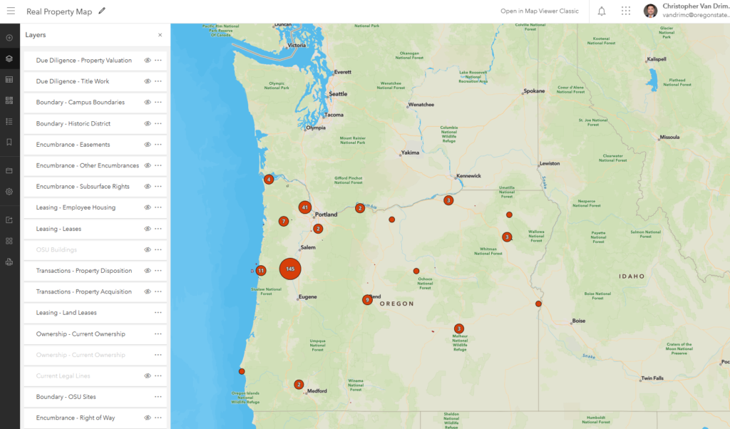
As of 2026, OSU owns over 26,000 acres throughout the state and maintains a leasing portfolio of about 250 agreements at any given time, roughly half of which involve OSU as the lessor/grantor, and half where OSU is lessee/grantee. With such a vast and far reaching real property portfolio, effective decision making must inherently involve the ability to think spatially regarding each asset and how location based factors play a critical role in the use, management, and optimization of each.
The history of land asset tracking and management at OSU is somewhat unique in that the state of Oregon had a unified university system that operated under the auspices of the State Board of Higher Education from 1929 to 2014. When the Board was established, many functions, including real property, were assumed and administered centrally rather than by the individual campuses. What became the Oregon University System (the administrative arm of the Board of Higher Education) used a “land card” system to record all real property transactions for all member institutions – quite literally a card catalog until about the year 2000 when these cards were entered into a Microsoft Access database. In 2011, the University of Oregon advocated for the legislature to give universities the option to opt-out of oversight by the Board of Higher Education, instead forming their own, individual Boards of Trustees. In 2013, OSU, Portland State University, and UO all opted for independent boards, with the remaining regional universities opting for the same one year later, and by July 1, 2014, the Board of Higher Education and the University System officially ceased to exist. Universities were now all in charge of their own individual property portfolios, with paper deed, title, and other records delivered to the individual campuses without further guidance.
2020 brought the most destructive wildfire season on record to date with over one million acres burned throughout Oregon. As Oregon’s land grant university, with operations all over the state, university leaders came to the Real Property unit with the question “what of ours is in danger out there?” With a file cabinet full of paper deed records as the primary source of truth for university property ownership, no easy or quick answers to this question existed and this became the initial impetus for the Real Property Map system.
The RP Map system’s first phase was built from Fall 2023 – Spring 2025 and initially focused on answering the question “what do we own, and where is it located?” OSU Campus GIS was able to provide Real Property with an initial “best estimate” dataset based on a county-by-county “data scrape” for parcels that appeared to be OSU owned based on assessor information. This yielded about 16,000 acres of land initially though to be OSU owned, however the data was of variable quality and needed significant verification.
Using the aforementioned paper deed records (which had been digitized from 2020-2021) from OUS, as well as OSU’s own records for transactions from 2013 forward to simultaneously build a layer of all OSU property acquisitions from 1886 to present and verify the estimated current ownership layer, all of which was constructed in ArcGIS Pro and published to OSU’s ArcGIS Enterprise Portal. Upon completion of the Property Acquisition layer, the Current Ownership layer had grown to over 20,000 acres with a very high degree of confidence in completeness. All entries in this layer also link back to the deed of record for the transaction as attached files, enabling easy look up and reference.
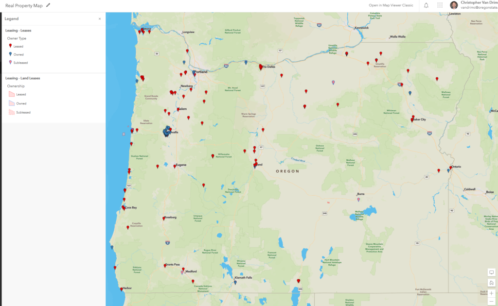
At the same time, a leasing layer was imported from the university’s VisualLease system in order to enable overlay of ownership and leasing data. While VisualLease remains the system of record for leases, a full picture of OSU’s Real Property portfolio would be incomplete if it contained only ownership data. VisualLease’s built in geocoding tools make this type of interoperability with GIS systems very simple.
Once the question of “where” had been comprehensively answered, attention turned to the questions of “what” and “how.” “What” did OSU have on its property, and “how” does this affect use? OSU Campus GIS has long worked to address “what” in the form of building and other improvements layers, however from a real property and land use perspective, much of “what” and “how” are not tangible objects, but take the form of easements, restrictions, and other forms of encumbrance that are nevertheless deeply tied to a real world location. Over 400 easements and other exceptions to title were mapped from recorded documents, giving the ability to visualize where other entities have rights to OSU ground.
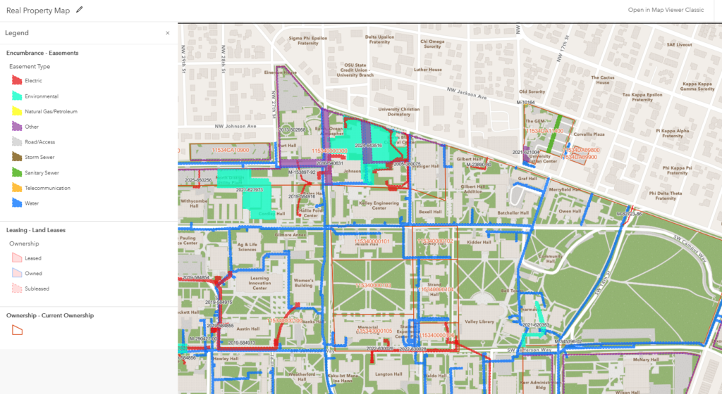
As with acquisitions, easement records also link to the recorded documents as attachments, enabling easy lookup and reference.
Further encumbrance layers have been added over time, such as CC&Rs, land use restrictions, other non-easement encumbrances, subsurface rights, and right-of-way dedications. As of this writing, the OSU RP Map system documents the following:
- Due Diligence
- Title Work
- Property Valuation
- Boundaries
- Campus Boundaries
- Site Names/Boundaries
- Historic District
- Encumberance
- Easements
- Non-Easement Exceptions to Title
- Subsurface Rights
- Right-of-way
- Leasing
- Leases
- Land Lease Areas
- Employee Housing
- Transactions
- Property Acquisition
- Property Disposition
- Internal Land Allocations
- Ownership
- Current Ownership (as both points and polygons)
- Current Legal Lines (to account for replats/subdivisions)
- Partner Unit Data
- Unimproved Land Area
- Tree Canopy
- Open Space/Greenspace
- Protected Land Areas
The OSU RP Map system has garnered interest from other universities and public agencies. Demonstrations and guidance on construction of a similar system have been provided to:
- University of Alaska – Anchorage
- Utah State University
- Oregon Department of Fish & Wildlife
Many thanks to the Ohio State University Planning, Architecture, and Real Estate (PARE) team for their guidance in the initial planning of the OSU RP Map system. The RP Map is heavily based on the layers and data schema used in the Ohio State University PARE Map, also constructed using ArcGIS Pro and ArcGIS Online.