
Albany, Oregon has a lot to recommend it as a place to live. Ideally situated in the Mid-Willamette Valley, it’s within easy distance of the coast and the mountains, practically right next door to Oregon State University in Corvallis, and three of Oregon’s major cities, Salem, Eugene, and Portland can be reached inside of 90 minutes (which also puts Albany within the service area of not one, but two commercial airports). In a lot of ways, Albany reaps the benefits of being centrally located, but without some of the tradeoffs that come with living in a larger city. But how easy is Albany to navigate within the community itself?
At a recent City Council meeting, city staff provided a preview of community feedback related to the new strategic plan that the city is constructing. Of particular interest was input from young Albany residents when staff visited the high schools looking for feedback on what the next generation wants out of their city. Staff relayed to council that younger residents are not interested in driving to get where they need to be, or in many cases even interested in learning to drive at all, so walkability and transit are important issues, and will likely become more important to the general community as this generation moved into adulthood. This is in line with national trends as highlighted in the USA Today Article: Generation Z is less likely to have a driver’s license. Here’s why.
Based on this, one can measure “walkability” using a set of criteria. There are, of course, websites which will provide a “walk score” of particular communities, however the methodology by which these scores are generated is not always clear, and comparing communities involves a shared understanding of what exactly it is that we’re comparing. Bear in mind that the below is one measure of “walkability,” and cannot measure all outcomes. In particular, employment as a function of walkability is specifically excluded from this analysis, as the question of whether or not one’s job is within walking distance (or even should be) is more complex than other factors.
A walkable community is one in which necessary services and community resources can be accessed within a reasonable walking distance from one’s home. “Reasonable” will vary from person to person, but for the purpose of this analysis, a 15 minute walk time is used to generate the “service area” of three key services and resources: schools, parks, and grocery stores.
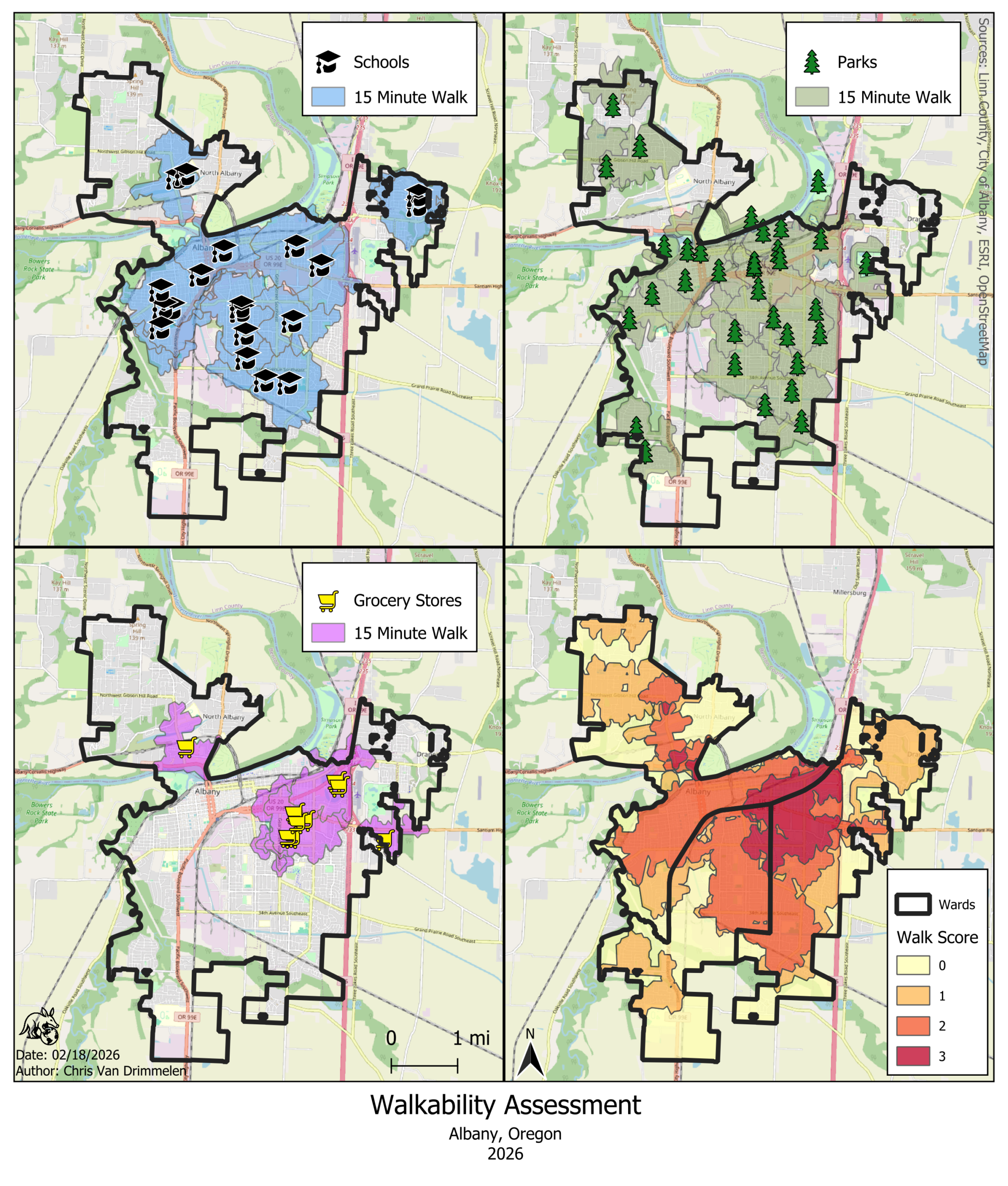
The above service areas for each location have been overlaid and turned into an index score ranging from 0-3, indicating how many essential services or amenities one can reach within 15 minutes within that area. The dark red area indicating the highest possible walkability index is fairly small and occurs predominantly in the eastern part of Albany, with small pockets of index 3 around the North Albany Village shopping center. Albany’s eastern Ward 3 his the greatest proportion of the city’s high walkability area, with the southwestern Ward 2 having the smallest. Apportioning 2025 population data to the areas of highest walkability, only just under 13% of the population of the city lives within a “highly walkable area.”
Apart from indicating where the most walkable areas of Albany are, this index also reveals a couple of things about the city:
- Walkability is highly dependent upon the location of grocery stores. Albany’s schools and parks are distributed throughout the city, and Albany has even been described as “over parked” for its population, a fact that the city can be proud of, but with only 9 grocery retailers who are tightly clustered in one area (with one exception in North Albany), it is not realistic for vast swaths of the population to walk to a grocery store.
- There are significant portions of Albany that could be immediately upgraded to the highest category of walkability if a grocery store were to move into said areas.

The map above overlays “underserved areas” and “zones of opportunity.” The underserved areas are predominantly walk score 0 or 1, and represent the least walkable areas of the community, while the Zones of Opportunity represent areas where the vast majority of the area receives a walk score of 2, meaning that these areas could be upgraded to a 3 by the addition of the final “missing” service.
Underserved Areas:
East Albany: This area is characterized by more recent development, with more on the way as proposed in the form East Albany Area Plan, some concepts for which would add over 1,000 housing units as part of a “village center” of mixed use residential/commercial. Ongoing development may be on the way to addressing deficiencies in walkability in this area.
North Albany: This area is possibly the most difficult to address walkability in because of a combination of hilly topography and “organic” development that took place prior to the area’s annexation into the city. Many roads in this area lack city sidewalks, and steep slopes present accessibility challenges. Solutions for this area may need to combine both transit and walkability to be effective.
West Albany: This area includes much of Albany’s industrial zone, so a lower walk score is partially to be expected, yet at the same time, West Albany is home to a sizable population of residents who do not reap the same walkability benefits as residents closer to Albany’s core. The low relative population density in this area may make short term solutions more limited, but this is an important population to consider in the overall discussion.
Zones of Opportunity:
Central Albany: This area encompasses Albany’s historic downtown and adjacent neighborhoods. This area is already known to be one of the most walkable areas of the city in general, but could be improved to the highest level with better access to services. While the majority of the area is either residential or the downtown Central Business District, the zone does extend as far as the commercial corridor along Pacific Boulevard, presenting possible opportunities along that particular edge of the zone.
South Albany: This area is comprised of large tracts of single and multi-family residential development that has built out as the city has expanded over the years. As development has happened further and further from the city’s core, access to services has not moved south in a commensurate fashion.
While this analysis does reveal a major deficiency in the walkability of Albany, primarily related to access to grocery stores, it also demonstrates a major opportunity to improve quality of life in the community if the community can persuade or incentivize retailers to come and set up shop.
It may not be a completely realistic scenario, but it is an interesting thought experiment to consider what life in Albany would look like adding all of the estimated population of the two zones of opportunity to the highest category of walkability – approximately 24,424 people, or over 39% of Albany’s total population. Coupled with the existing almost 13% already in that category it could make Albany a leader in this area.
Coming soon: How does Albany’s walkability compare?