
Previously, walkability in Albany, Oregon was analyzed in the post How Walkable is Albany?, with the walk index analysis indicating that only about 13% of the city’s population live in a highly walkable area where one can access services and amenities within a 15 minute walk of one’s residence. While as a raw percentage, this may seem low to the reader, in order to place that in context, some benchmarking and comparison is necessary.
In order to establish reasonable comparisons, four other mid-valley cities were selected and subjected to the same walk-score analysis using parks, schools, and grocery stores as facilities that contribute to walkability. Please see the previous post for a complete discussion of how the walk score is constructed.
Comparator communities were selected on the basis of both proximity to Albany, and an attempt to use communities of a similar size and scope where possible. It should be noted that a list of communities of similar size to Albany is quite short, even when one considers the entire state of Oregon. There are five cities in the entire state that fall within the range of approximately 50,000-100,000 (Tigard, Albany, Corvallis, Springfield, and Medford as of the time of this writing). Medford lacks regional proximity to the mid-valley, making comparison more challenging, and Tigard is part of the Portland Metro area, which also introduces factors that make direct comparison difficult. For this reason, these communities are excluded from the comparison in favor of two smaller, but more geographically proximate communities, Lebanon and Keizer, based on Tobler’s First Law of Geography:
Everything is related to everything else, but near things are more related than distant things.
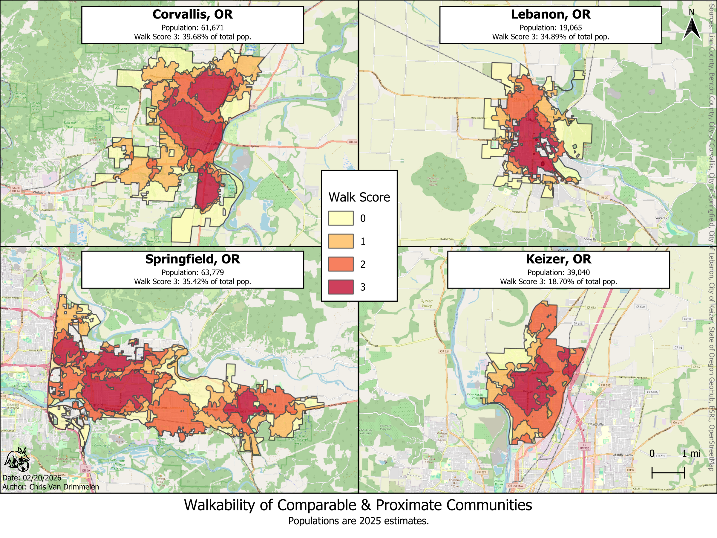
Corvallis and Springfield serve as Albany’s two closest geographic comparators (approx. 10 miles and 45 miles from Albany respectively), and have population sizes in the same approximate range as Albany.
Lebanon and Keizer (approximately 15 miles and 30 miles away respectively) are both less populous than Albany, and smaller communities may face fewer barriers to walkability due to their ability to remain geographically more compact, however regional similarities mean that these two additional mid-valley cities may add to the comparison without having to drive it.
All four communities fare better than Albany on the same walk score analysis to one degree or another. Keizer came out the most similar to Albany at just under 19% of the population living in an area with a walk score of 3, while Lebanon and Springfield both fell near 35% in the same category. Corvallis came out on top with nearly 40% of the city’s population in a highly walkable area of the city. Albany does not fare well in this comparison, falling below all comparator communities.
Recalling from the previous post, highly walkable areas in Albany were closely correlated to grocery access, as the city’s limited number of tightly clustered grocery stores formed the limiting factor in boosting most areas from a walk score of 2 to 3:
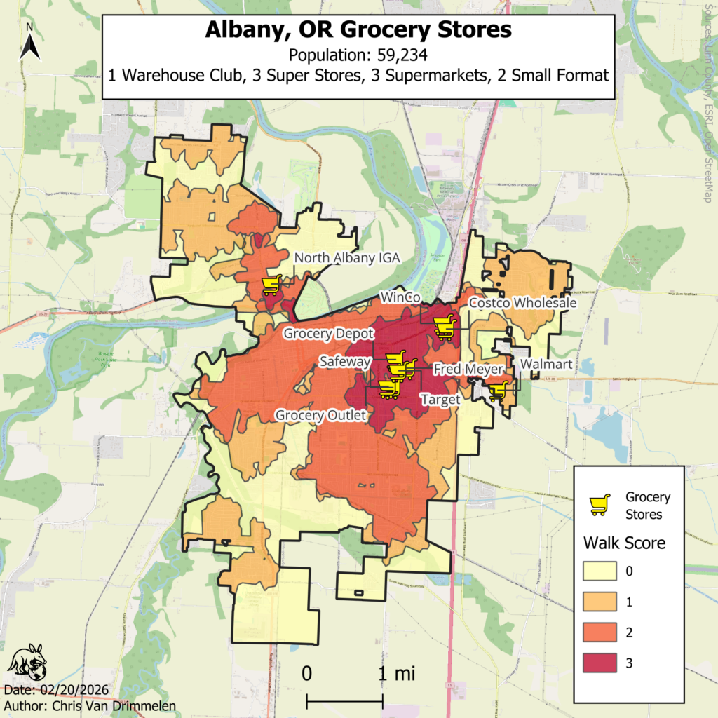
The store type category definitions used in the above map subtitle will be discussed in detail in a subsequent post.
The next step is to establish if the pattern that we see in Albany where grocery availability creates a “limiting factor” and is highly correlated with areas with the highest walkability:
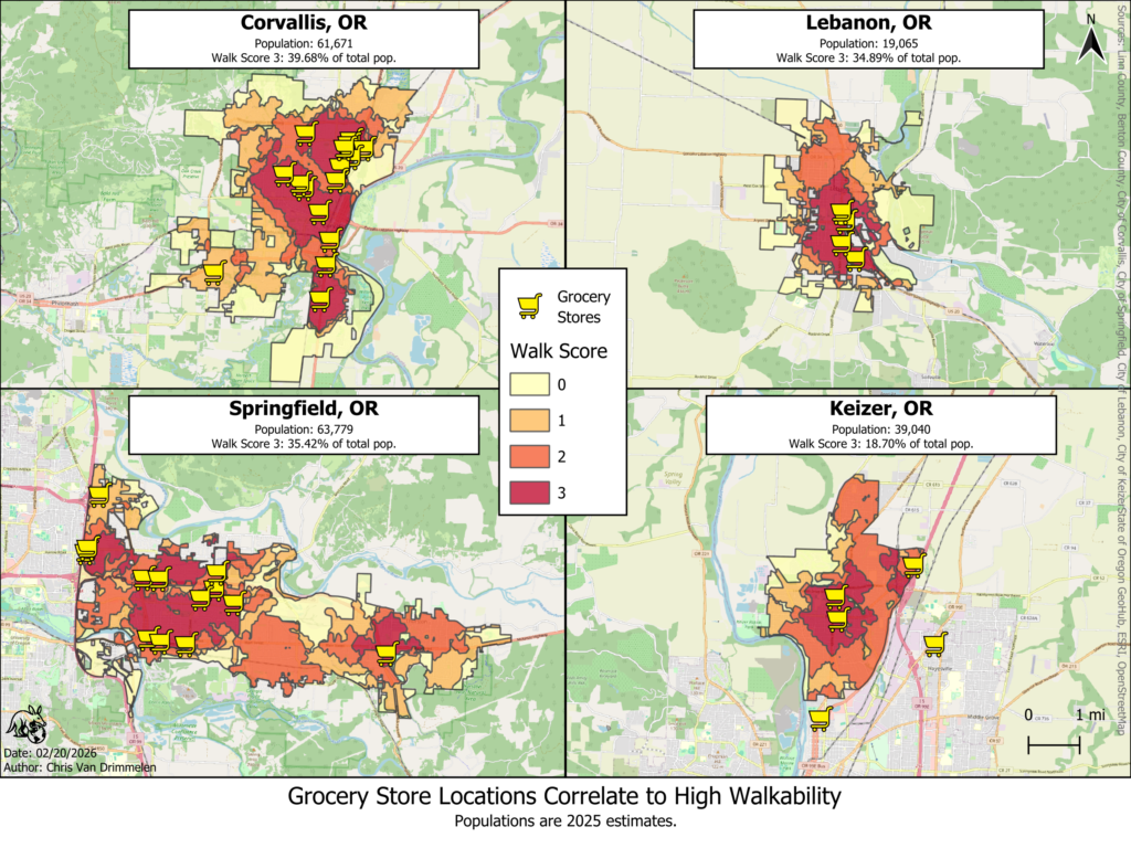
It is readily apparent upon overlaying grocery store locations in the four comparator communities that the same pattern of high walkability correlating with the presence of grocery stores bears out in all four cities. A quick count of locations in the most comparable communities, Corvallis and Springfield, also reveals considerably more grocery stores than the 9 that Albany boasts: 13 locations in Springfield and 16 in Corvallis. Initial indicators point to something inconsistent about how grocery retailers treat Albany as a market compared to similar communities.
Coming Soon: Analysis of the number, type, and location of grocery stores in comparator communities.